
Use cases | 22 November 2019
Testimonial: ReintenInfra - Visualization of public space
As a contractor in infrastructure, ReintenInfra focuses on installing layouts for public space. They are also increasingly faced with the design challenge of the public space. That is why ReintenInfra is working on innovating in the field of BIM and the 3D elaboration of the design question.
Maurits Koenders, Designer at the engineering firm of Dusseldorp ISM (part of ReintenInfra), tells us more about the added value of Cyclomedia LiDAR Point Cloud within this development.
Visualizing the existing situation
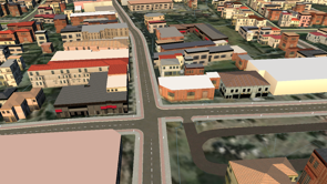
For ReintenInfra, the added value of the Cyclomedia LiDAR Point Cloud is mainly in the visualization of the existing situation in a 3D environment. This 3D environment can be used in the planning stage to communicate our ideas and vision for a project. This is often done as a sketch, because no detailed design models have yet been created.
Simplifying the communication
After the tender, during the detailing of the design, ReintenIfnra uses the Cyclomedia LiDAR Point Cloud, to project 3D design models in the environment, thereby simplifying and clarifying the communication. The design 'comes to life' more fully.
Applying the Collaboration LiDAR Point Cloud offers considerable added value in the field of communication with both clients and stakeholders. Almost everyone understands a 3D drawing, whereas a 2D design drawing is difficult to fully understand for many people.
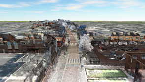
Using the Cyclomedia LiDAR Point Cloud, the 3D environment is upgraded from an abstract representation of the outdoor area to a 3D environment in which the existing situation is portrayed realistically. This makes the model recognizable to everyone.
The future calls
ReintenInfra is very busy innovating in this field, and the first applications they have used during a pilot project have been included here. These applications are just a prelude to what will be developed in the near future.
Think of classifying the point clouds and the translating the point cloud into closed 3D planes. In the future, ReintenInfra will be increasingly using this data and further utilizing the possibilities it offers. Think of 4D planning, visualizations, VR options, etc. The future calls!