Blog | 28 June 2022
Phase 1: Re-imagining Mobile Field Work for Next-Gen Networks
Phase 1: Planning
When it comes time to begin the daunting task of planning your new fiber project, where do you even begin? Successfully navigating myriad factors in planning of FTTX networks are crucial for the ultimate success of the project. Accordingly, enabling data driven, informed decisions from the start of the project has a direct impact on the downstream project schedule and budget.
What tools are needed when beginning to plan your fiber route? Access to accurate ground-truth information is not only necessary but critical. The historical paradigm of sending crews out to the field to gather this information can be time-consuming, costly and pose a safety risk to crew members. One client of Cyclomedia describes the process this way:
“Combine a CSP’s imperfect knowledge of its assets with that of the environment and the context in which they exist, and it’s not surprising how nearly impossible it is to anticipate obstacles or factors that could aid in their rollout of a network.”

What if there was a way to visualize premise and access information and site conditions remotely without leaving the office? Avoid pre-planning field walkouts? Fortunately, there is. Cyclomedia’s high resolution imagery solutions enable you to verify premise types and counts and access conditions during the feasibility assessment and estimating stage. It can also help planners avoid surprises that could cause downstream delays and cost overruns during deployment.
Planning can be even more challenging in northern climates where inclement weather shortens the window for outdoor work. One of Cyclomedia’s clients, a large construction and engineering firm, discovered and documented that they gained significant efficiencies by doing their design work in the office during the winter months using immersive high resolution imagery that was recently collected. The lead engineer at the firm is on the record saying:
“The data we get from Cyclomedia is fresh, it’s good for at least six months and often for a full year. This allows us to plan and model the network in the winter without having to go out into the cold and adversities, and be ready to break ground when the weather is ideal.”
Street-level Perspective Enables Effective Planning
CSPs and engineering firms can use the imagery to help determine whether a potential route contains the critical mass of residences and businesses necessary to make the rollout profitable. Access to this street-level perspective enables better informed decisions related to the network type and placement, and identifying obstacles that can affect the cost and complexity of the desired route. The street-level perspective also provides detailed and accurate visuals for of poles, equipment, surface types and includes views under bridges, tree canopies and other overhead structures commonly obscured from aerial images.
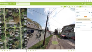
Street Smart™ Web Application for Desktop Survey
Strategic network planning has never been more accessible or efficient than with Cyclomedia’s imagery-viewing web application, Street Smart. The immersive street-level view, combined with the high-resolution of the imagery, delivers high confidence desktop verification of the real world. This user friendly application offers functionality such as high accuracy measurement capabilities and the ability to overlay 3D data. What historically required ire sending an engineer to the field can now be done quickly and safely from the desktop.
The power of Street Smart extends beyond the core web application into pre-built integrations and an open API for access to the imagery within the most widely used GIS or CAD applications. With the integrations, edits can be made using the street-level imagery and you can automatically update your existing database. This brings the street-level view right into your current planning platforms to enhance workflows and visualize the real world without leaving the office.
In summary, project success hinges upon the fundamental decisions about where and how to deploy a fiber network that are made during the initial planning phase. Having access to the right data and actionable intelligence at this stage has a significant impact on the overall success of all downstream activities and the overall deployment. By partnering with Cyclomedia, you can move confidently from the planning stage into the High-Level Design phase of your fiber network rollout.

About Jill Scharbarth
Jill has been with Cyclomedia for 4 years; she focuses on helping telecommunication and utility clients find the solutions they need to solve their problems. As a Solution Engineer, she works to understand client needs and integrate Cyclomedia’s solution into current or new workflows. Jill’s prior experience with data analytics allows her to better help clients find the right fit for their project needs.

About Scott Casey
Scott has over 30 years experience in the utility and communications industries creating long-term technology value and transformative solution impact. His expertise is focused around enterprise geospatial software for engineering, operations and asset management. Scott strives to bring new and innovative geospatial and location intelligence solutions to utility, cable and telecom clients.