City Positioner
Superb urban area positional quality
What is City Positioner?
A city never sleeps. Hundreds of thousands of people work and live in large cities every day. In order to guide all these flows in the right direction, a great deal of flexibility is required from local authorities.
In order to make decisions based on data that, for example, contribute to traffic safety, sustainability or better telecommunications, it is important that the image data from the outside world that local authorities use, is accurate and reliable. City Positioner is the solution that ensures that the outside world really matches with it's digital twin on your desktop.
City Positioner corrects any deviations of the digital twin of your city. We do this by matching the data collected from street level with the data that has been collected from a bird's-eye view by Cyclomedia. These two layers are overlaid and corrected where necessary. This allows you as a local government to really make a difference and to flow in the same speed as your city does.
Why it matters

Errors in the position of recording locations will lead to errors in, for example, the location of detected traffic signs, road markings, measurements and in the visualization of overlays.
A position quality with a maximum deviation of 10 cm from reality is required to support data-based changes in a city. Without this reliable data, there is a high probability of making decisions in the form of large projects that cannot be implemented correctly because the data source is not geometrically correct. This costs an enormous amount of time and money that could have been better spent.
Reference case: Berlin
What we did in Berlin, Germany
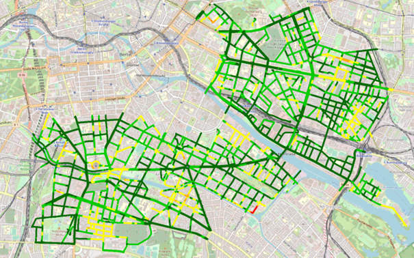
We calculated the coordinates for a dataset covering the city center of Berlin. A comparison showed that in almost 17% of the recordings a correction of more than 3.93 inch was calculated. In less than 1% of the cases a correction of more than 9.84 inch was calculated.
What does this mean?
Even in a large city like Berlin, where we had not yet used our City Positioner technology, we fulfilled the promise of providing data with an average standard deviation of 0.39 inch.
When we did apply the City Positioner technology, we came very close to the goal of delivering data with a maximum standard deviation of 3.93 inch. Even in places where very good aerial data could be acquired, we were able to deliver data with a standard deviation of 1.96 inch.

Difference in Berlin in position calculation with and without use of City Positioner technology
- Dark green a correction of less than 1.96 inches
- Light green between 1.96 and 3.93 inches
- Yellow between 3.93 and 9.84 inches
- Orange between 9.84 and 19.86 inches
- Red over 19.86 inches
