Blog | 12 August 2022
Phase 2: Re-imagining Mobile Field Work for Next-Gen Networks
Phase 2: Design & Engineering

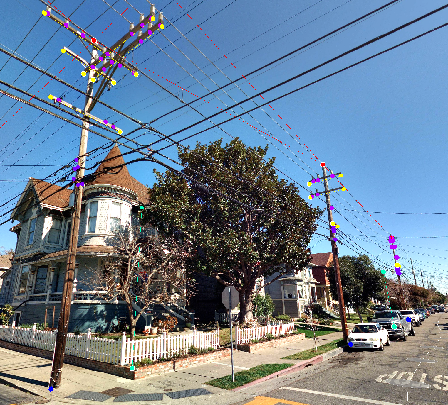
Now that your fiber project is past the initial planning phase, it’s time to dig into the design and engineering phase. Knowledge about the route and any existing infrastructure is crucial at this point. A FTTX network must be designed to leverage existing infrastructure and account for the true field conditions in order to optimize materials and cost. Designing on an accurate base map, including 3D information, eliminates inevitable mistakes and surprises down the road. We have all heard the saying “Garbage in, garbage out” – the input data you start with needs to meet tight accuracy and completeness standards to be a reliable base map reference for the design. While street-level imagery and LiDAR provides an immersive view of site conditions, the addition of highly accurate GIS asset and feature data can make the design and engineering process faster and more effective. Traditionally, this data is gathered in the field using “boots on the ground” resources with basic apps and handheld devices, whereas Cyclomedia’s advanced solution greatly accelerates the data capture and asset/feature identification, alleviating the time, cost and risk of sending crews into the field.
Case Study: CalComm Consulting
Earlier this year, Cyclomedia worked with CalComm Consulting, an engineering and consulting firm based in San Jose, California. CalComm was looking to add speed and digital twin capabilities to their engineering and design services for a large telecommunications provider.
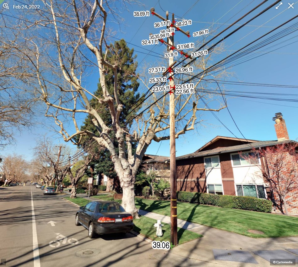
"Cyclomedia provides a complete replacement for field survey for all poles within the right of way," said Chris Van Ekelenburg, President at CalComm. "We teamed up with Cyclomedia for a project in California where we had to perform make ready engineering for thousands of utility poles for cable placement as part of a large FTTH deployment. Cyclomedia's team captured all data required for engineering every utility pole within the ROW," said Van Ekelenburg.
The impact to the project included productivity gains, higher quality data, and greater confidence in the results.
"During Cyclomedia's capture and extraction process, CalComm was able to commit our internal survey bandwidth on other projects, allowing us to scale our operations, increase revenue, and keep our clients happy.
Engineers have this insatiable appetite for precision and completeness: our Engineers were most impressed with Cyclomedia's ability to deliver on both regards. In addition to the accuracy and completeness of the data, our productivity as a team has increased over 30% and revision requests have dropped significantly."
- Chris Van Ekelenburg, President at CalComm

"One of our biggest strengths was having those pole annotations; we used them to verify points of attachment for pole loading and engineering reports; more accurate data means we can be more precise; having imagery data with the ability to measure helps immensely.”
- Chris Van Ekelenburg, President at CalComm
Data Insights for Efficient Engineering

Integrate digital field data into your GIS / CAD or workflow
Integrating the immersive virtual field experience with GIS and CAD tools is supported by a robust API that leverages common industry standards and brings the intuitive Street Smart 360º viewer and measurement tools right into the design process. On top of this, the extracted asset and feature vector data (points, lines and polygons with x/y/z coordinates) are provided in mainstream GIS formats that can easily be imported into the GIS or CAD platform and displayed within the 3D imagery. Service providers, utilities and engineering firms refer to this innovative and interactive approach as, “desktop review,” “virtual fielding,” and “the single source of truth.”
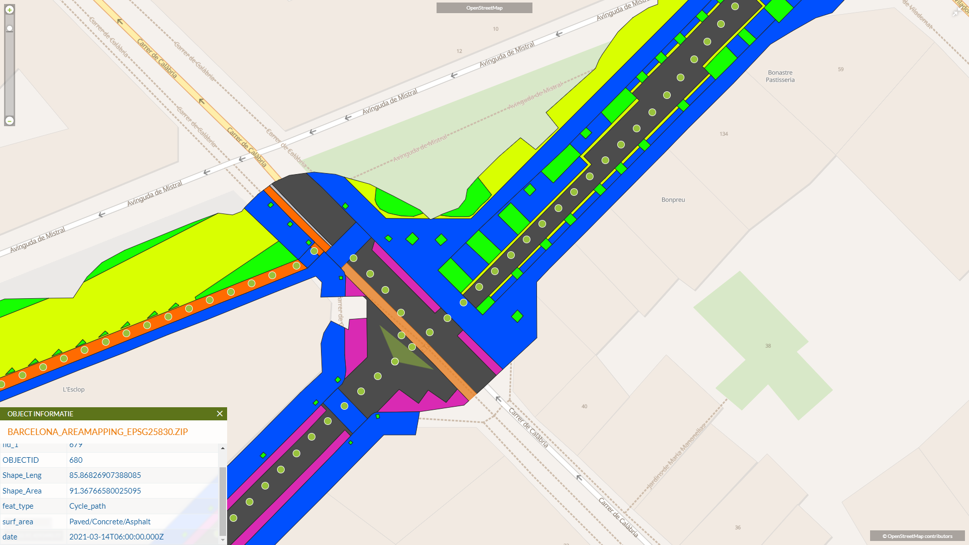
Need to know the surface types for better estimating? Cyclomedia’s Area Mapping product provides a fully-automated identification of surface type within the street and right of way. The Area Mapping output is a polygon layer containing information on the area of each different surface, type of feature, and type of surface within that feature. This is a great option as a base layer when working through the design and engineering process.
Interested in learning more?
In September, the third and final part in this series will dive into the permitting process where we see the need for precise measurements, verification of regulatory compliance, and detailed plans for any potential impact to utilities, roads, sidewalks, landscaping, and structures.

About Scott Casey
Scott has over 30 years experience in the utility and communications industries creating long-term technology value and transformative solution impact. His expertise is focused around enterprise geospatial software for engineering, operations and asset management. Scott strives to bring new and innovative geospatial and location intelligence solutions to telecom, cable, and utility clients.

About Chris Van Ekelenburg
Chris is President of CalComm, an engineering and consulting business whose mission is to enable effective deployment of the world’s telecommunications infrastructure. As an engineering supplier to many of the nation’s largest internet service providers, general contractors, and local governments, CalComm offers solutions for nearly all telecommunications applications. Services include: site survey and analysis, OSP/ISP detail engineering and design, permitting, make ready engineering, pole loading analysis, intrusive testing, and others. To learn more about CalComm, please visit www.calcommconsulting.com.