Heading 1
Heading 2
Heading 3
Heading 4
Heading 5
Heading 6
Lorem ipsum dolor sit amet, consectetur adipiscing elit, sed do eiusmod tempor incididunt ut labore et dolore magna aliqua. Ut enim ad minim veniam, quis nostrud exercitation ullamco laboris nisi ut aliquip ex ea commodo consequat. Duis aute irure dolor in reprehenderit in voluptate velit esse cillum dolore eu fugiat nulla pariatur.
Block quote
Ordered list
- Item 1
- Item 2
- Item 3
Unordered list
- Item A
- Item B
- Item C
Bold text
Emphasis
Superscript
Subscript
Our interactive viewer for all Cyclomedia content
Street Smart® brings 360° street‑level imagery, LiDAR data, and map layers together in a single browser‑based workspace. Inspect locations remotely, take accurate measurements, and share what you see with colleagues without leaving your desk.

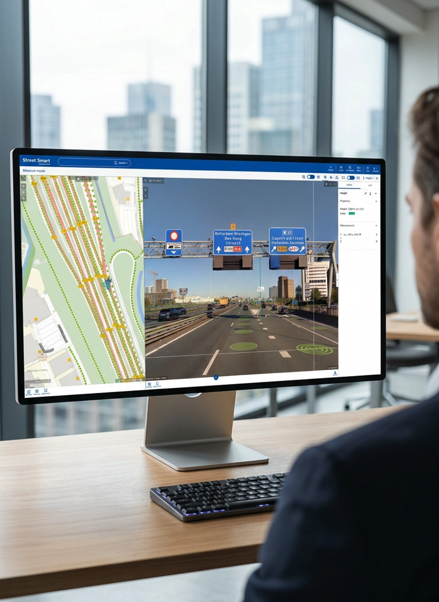

Street Smart®
50%
Accelerated desktop inspections.
Shift more work from the field to the office by using Street Smart® and work more efficiently.
100+
Integrations with GIS and systems.
Use Street Smart® alongside existing GIS, asset management, and analysis platforms without changing core workflows.
Bring the outside world directly into your planning, inspection, and design workflows
Street Smart® is Cyclomedia’s cloud‑based viewer for working with high quality street‑level imagery, LiDAR, and map data. It gives planners, engineers, assessors, and public safety teams a clear view of real‑world conditions so they can prepare work, review issues, and document decisions without repeated site visits.
Visual exploration
Navigate through your area using an interactive map and 360° imagery so you can understand surroundings, context, and constraints before anyone goes onsite.
Jump to locations. Pan, zoom, and rotate the imagery to inspect details from multiple angles. Use playlists or corridor‑style navigation to review long routes efficiently.
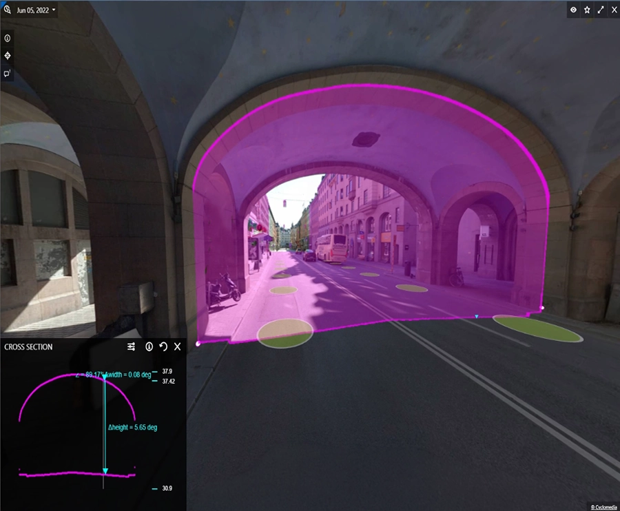
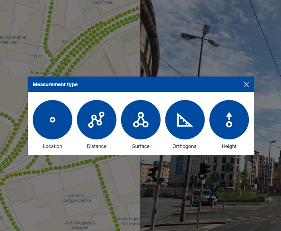
Accurate measurement
Use measurement tools designed for real‑world workflows to capture dimensions in imagery and on the map, supported by Cyclomedia’s depthmap, which embeds LiDAR accuracy into photo‑realistic imagery for easier interpretation.
Measure linear distances along façades, pavements, and openings. Calculate areas for surfaces such as parking lots, roofs, or work zones. Capture height and perpendicular measurements to support clearance checks.
Data layers & context
Overlay your GIS layers and object information on top of imagery. Combine your own datasets with Street Smart so you can see assets, attributes, boundaries, and 3D objects in context, validate information visually, and investigate issues faster.
Toggle basemaps and data layers to add cadastral, utility, or zoning context. View feature attributes from your GIS directly alongside the imagery.
Collaboration & reporting
Capture and share the current view so teams and stakeholders can work from the same information, whether you are documenting findings, preparing permits, or explaining options.
Generate shareable links that open Street Smart® at the exact same view. Download imagery or combined map‑and‑image snapshots for reports.
Turn street‑level imagery into practical insights for planning, safety, and asset management
Street Smart helps organizations reduce site visits, improve preparation, and communicate decisions clearly. By combining imagery, LiDAR, map layers, depthmap precision, and reporting tools, it becomes a shared visual reference for teams working on the same environment.
Reduce field visits
Answer many questions from your desk and reserve onsite work for tasks that truly require it.
Improve safety planning
Review approaches, clearances, and access points visually before sending crews or equipment onsite.
Support better decisions
Give planners, engineers, inspectors a clear, visual understanding of conditions to guide their choices.
Enhance communication
Share consistent views and exports so internal teams and external stakeholders discuss the same situation.
Strengthen documentation
Use imagery, measurements, and reports as visual evidence to support audits, permits, and project records.
Enable scalable oversight
Use the same viewer and data across neighborhoods, cities, or regions to monitor larger areas efficiently.