The Clock Is Ticking on MIRE
How Alabama DOT Closed a 100,000-Mile Data Gap Before the Federal Deadline.
Every state DOT in the country is racing toward the same deadline: September 30, 2026. That's when every state must have access to a complete collection of Model Inventory of Roadway Elements (MIRE) Fundamental Data Elements (FDE) on every public road, not just the interstate system.
For most states, that's tens of thousands of miles of roadway segments, intersections, ramps, and local roads that have never been systematically inventoried to this standard. Alabama's story shows what it actually takes to close that gap, and how modern data collection technology turned a stalled, decade-long effort into a near-complete dataset in 24 months.
Alabama's Long Road to MIRE Compliance
The Alabama Department of Transportation's (ALDOT) path to MIRE compliance stretched back over a decade:
- 2015: MIRE first introduced at a Highway Infrastructure Safety event in Alexandria, VA
- 2016: FHWA Division Office and ALDOT form a committee to scope the work
- 2022: Program restart, this time partnering with a university research team
- 2024: ALDOT attends a MIRE Peer Exchange in Oklahoma City, then makes a real investment and stands up a dedicated team
Manual Methods Simply Aren’t Viable
That timeline reflects a challenge familiar to nearly every state DOT: ALDOT’s MIRE collection kept stalling under the weight of manual field inspection. As ALDOT's own analysis put it, traditional collection methods meant high labor costs, safety risk to field crews, long project timelines, and limited scalability, all while the roadway network kept changing underneath them. By the time a manual collection effort finished one region, conditions elsewhere had already changed.
The scope of what ALDOT needed to inventory is staggering:
- More than 100,000 miles of public roadway
- Over 224,000 intersections
- 730,000+ intersection legs
- Tens of thousands of median-type segments
- Thousands of ramps across every functional class
A Modern, Multi-Partner Solution
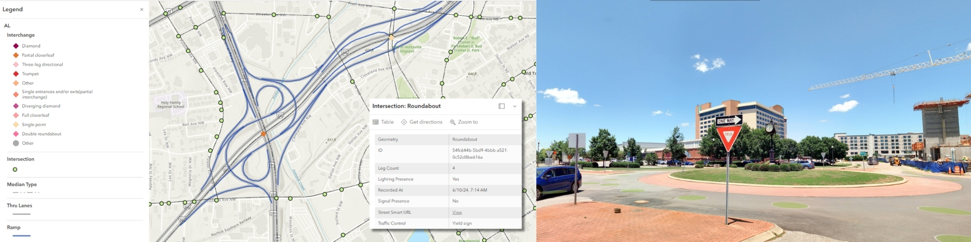
Rather than trying to close that gap with boots on the ground, ALDOT assembled a coalition of technology and data partners, each solving a different piece of the puzzle. Cyclomedia deployed mobile LiDAR and 360˚ street-level imagery collection combined with automated feature extraction and AI-assisted roadway asset identification to producing complete datasets for all non-local paved roads, including through-lane counts, one-way/two-way operations, median types, intersections and intersection legs, ramps, and pavement types. Instead of sending crews to physically measure and log each attribute, the roadway itself was captured once and the data was extracted from the collected LiDAR point cloud and 360˚ roadway imagery.
BIG Results
By pairing automated, remote data collection with targeted modeling and a dedicated internal team, ALDOT reported 94% completion of its MIRE FDE dataset with the finish line in sight well ahead of the federal deadline.
In 24 months, the team:
- Logged nearly 50,000 miles driven in support of data collection
- Captured over 2,100 HPMS sample sections
- Made more than 168,000 edits to HPMS roadway events
- Brought over 200,000 MIRE intersection and roadway segments under active management
"Through our partnership with Cyclomedia, we’ve been able to significantly reduce the manual burden associated with roadway data collection for ALDOT. Instead of relying heavily on crews to physically collect every data element in the field, Cyclomedia’s advanced imaging technology allows us to capture comprehensive roadway information efficiently and safely. This approach not only saves valuable time and resources, but also gives ALDOT access to more consistent, high-quality data to support safety analysis, asset management, and better transportation decisions."
- Brette Grant | ALDOT Assistant Bureau Chief, Surveying and Mapping
A Sustainable Model
Alabama is far from the only state facing this deadline, and the underlying challenge is the same everywhere: manual field collection simply doesn't scale to "every public road in the state" on a fixed timeline and a constrained budget. The states that successfully cross the “finish line” will be the ones that combine automated, remote-sensing data collection with the right analytical and modeling partners, turning a compliance deadline into a durable, reusable safety data asset.
Automated data collection didn't just help ALDOT check a regulatory box. It gave the department better data, lower long-term costs, less field exposure for employees, and ultimately a stronger foundation for the safety analysis that MIRE was designed to support in the first place.
With September 30, 2026 fast approaching, any state DOT that hasn't yet closed its MIRE FDE gap has a narrowing window to act. Alabama's experience offers a clear blueprint: automate the collection, bring in the right partners, and treat the resulting dataset as an ongoing asset - not a one-time deliverable.
Interested in how automated mobile mapping and AI-assisted feature extraction can help your state close its MIRE FDE gap? Connect with us to learn how we supported ALDOT's effort.
Explore the additional ways we empower DOTs and transportation agencies by visiting our transportation page.