Blog | 29 December 2022
Phase 3: Reimagining Mobile Field Work for Next-Gen Networks
Phase 3: Low-Level Design & Pole Engineering
There are two things in limited supply when completing detailed design and pole engineering packages: time and resources. Cyclomedia reduces considerable time and effort in the design and engineering work cycles by streamlining the production and integration of high-quality field data while eliminating 80-90% of manual field walkouts.
With the initial high-level design visual inspection in the previous phase completed using Cyclomedia’s online Street Smart application and key asset/feature data identified through analytics extraction; it is time to dive into the details. To get permits successfully approved in a timely manner, the accuracy of the data and the quality of the engineering package are key. Submitted plans must include precise measurements based on extensive knowledge of the existing site conditions and proposed build. It is also important at this stage to have an up-to-date and reliable basemap for the intricate design and engineering work. Whether focusing on overhead or underground design, the permitting process can be daunting, but with Cyclomedia’s help it can become a lot easier.
Underground Solutions
When designing an underground route, small details are a big deal. Once you are down into the low-level design, an understanding of the surface materials and the ability to accurately measure precise network positions and offsets is central to producing a “construction ready” design package.
Street Ortho Product for Detailed Design
Imagine an orthophoto taken just feet off the ground and free from overhead obstructions. Using our own street-level imagery and LiDAR data, we generate true high-resolution orthophotos with two-centimeter pixel resolution and positional accuracy of 10 centimeters. The Street Ortho product enables highly detailed visualizations of all features within the right of way, making it the perfect basemap for low level network design. Delivered in a GeoTIFF format, Street Ortho can be ingested as a base layer into any CAD or GIS, allowing users to easily make precise measurements and design directly onto an accurate real-world image.

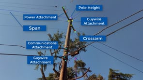
Overhead Solutions
When planning for an overbuild, there are a host of pole inventory and assessment attributes that must be identified and incorporated into the engineering and permit packages. These often include images of each pole in question with annotations denoting the heights and types of all existing attachments. Generating these images can be an extremely tedious process costing precious man hours and delaying project approval. Cyclomedia’s solution can include the attachment height information overlaid within the 360-degree street-level imagery to verify the existing attachments and comply with regulatory and permit requirements, saving our clients plenty of time and resources.

Cyclomedia has a common list of assets and attributes that feed into several different pole engineering use cases, including extracted features such as pole characteristics, communications and power attachments, anchors, guywires, crossarms, spans, and vertical clearances.
Make-Ready Assessment
Make-ready engineering assessment and preparation requires precise and reliable information on pole suitability for new attachments, based on compliance with regulations and engineering specifications that all stakeholders can objectively rely on – and most importantly agree on. The key stakeholders include owners, joint owners, attachment requesters, and engineering and construction firms. Cyclomedia’s Pole Details extraction provides accurate 3D GIS data on pole characteristics, attachment heights and types, all the clearances required for make-ready assessment, and high-resolution imagery for visual verification by all constituents.
Pole Loading Analysis
Expanding a fiber network often includes leveraging existing overhead infrastructure where burying is too costly or not an option. Having accurate details on existing pole characteristics, spans, anchors, and load-bearing attachments is mandatory for pole engineering analysis programs. Cyclomedia performs data analytics on the LiDAR and imagery to extract the information required to feed into loading analysis platforms, streamlining the process and avoiding having to send workers into the field.
Joint-Use Inventory
With utility poles being heavily utilized and overcrowded, documentation on attachments is typically incomplete and out of date. It can be nearly impossible to properly track and record all the cable and equipment attachments and their owners. A comprehensive pole inventory is necessary prior to any network expansion where access to existing attachments is required. Cyclomedia’s patented imagery and LiDAR capture and processing technology combined with advanced data analytics provides the pole inventory at scale with far less time and effort and with much greater quality.
Forever Forward
Cyclomedia’s innovation goes well beyond the FTTX plan, design, engineer, and permit cycles. To maximize the value of our data, service providers can easily make the immersive visual 3D capabilities and asset insights available across departments and use cases such as: ongoing network maintenance, regulatory compliance, risk assessment, customer service, and more. Cyclomedia’s data can become a basis for a true and accurate 3D digital twin. Our continuous application of advanced R&D in the areas of machine learning and automation keeps the focus on innovation to find even better ways to solve the issues that face our world.
The team at Cyclomedia would be pleased to provide an in-depth review of the end-to-end solutions and use cases across the planning, high-level design, low-level design/engineering, and permitting phases. For more, please visit our website at www.cyclomedia.com/us/pole-management.