Blog | 08 February 2023
Road Surface Analysis Blog
Roads shape the reputation of a Smart City
“This was told to me by a Public Works Director at my first conference in the US,” said Doekele Rienks, Director of Product Management, who came to work at the US Cyclomedia headquarters from the Netherlands. “Fresh from the Netherlands, I quickly understood that roads are extremely important in the US. Without a car, it is difficult to get, well, anywhere! And what do cars require? That’s right- roads that are in good enough shape to drive on. But what is the reality of road conditions in the US? There is a huge difference in the quality of roads in the US, which became clear to me when I immediately hit my first real pothole leaving the Chicago airport. Luckily, I was driving a rental!”
Considering the high number of miles of roads that exist in the US, it is logical that the quality of roads will differ from place to place. Many factors impact this, such as differences in climate, road use intensity, and available maintenance budgets. But despite the fact that these factors are outside of our control, it doesn’t change the fact that a city is often judged on the quality of its roads. The question that needs to be answered is: How can a Public Works department strategically achieve the best overall road network quality within their jurisdiction? Sometimes, due to the available resources (or lack thereof), it is easier to simply let a road remain 'bad', but that does not mean that the city should have a bad reputation due to something outside of their control.
Pavement Preservation Strategy
After attending various conferences and learning about the issues faced by Public Works departments when it comes to preserving the roads, Doekele has learned a lot about what goes into an effective road-preservation strategy. “One of my major insights over the past 3 years is that a city that does NOT spend its budget on the worst roads is a Smart City! To me they are smart because they probably have a data-driven, long-term pavement preservation strategy for their roads.” Such a strategy means that the available budget for road maintenance is used in the places that achieve the best possible overall Pavement Condition Index (PCI) in the long term. This often means that a road that is already deteriorated is not immediately fixed, but rather one that has just began to crumble. However, deciding which roads to address first means that cities need quality data in order to build a good pavement preservation strategy and multi-year plan. But how can they collect this data?
Unique Collaboration
“Despite not having a background in Public Works or pavement management, I have gained the necessary experience to work in this interesting field in my recent years with Cyclomedia,” says Doekele. “When I joined Cyclomedia as Product Manager Data Insights, the first product I worked on was the Road Surface Analysis (RSA) product, which Cyclomedia developed together with Arcadis. This unique collaboration has been successful because two fields of expertise came together, resulting in a product that uses the newest AI technology available.”
Cyclomedia’s first-in-class, high-resolution images and LiDAR point cloud lend themselves perfectly to recognizing road defects. But when it comes to assessing road surface damage and assigning a severity class according to the applicable national methodology in play, you need more Subject Matter Expertise (SME). As a leading consultancy firm, Arcadis brings the needed SME into this collaboration, which has been underway for 3 years now.
“In those 3 years I have been able to do specific courses in Pavement Condition Assessment, giving me some basic knowledge about this interesting working field. But to be honest, I have not even come close to knowing as much as the Arcadis Road inspectors do!”

From Subjective to Objective
“Another thing learned in my time at Cyclomedia is that many road inspections still take place via an 'old-fashioned' visual inspection, due to budgets that do not allow for a full road scan.” Although on-site visual inspections are acceptable, cities need to keep in mind that the results of an ‘on-site’ inspection are subjective, as each individual inspector looks at a road with a different set of eyes. In addition, the same inspector will see a road differently on a Friday morning after a late night out than they will on a Tuesday morning after a good night of sleep. What do they perceive as “problem areas”? How do they assess severity? Are there issues and damages that they missed? To a human inspector, the answers are often subjective.
Keeping this in mind, it makes perfect sense to have a computer inspect road surface damages. By training AI to detect road damages and their severity, we can move from a subjective scoring to an objective one, free from human error- this is exactly what Cyclomedia has accomplished with our RSA product.
To do this, we added the knowledge and years of experience belonging to the Arcadis Road inspectors to our RSA algorithm. The algorithm was trained with the RSA data collected by the inspectors, resulting in an AI driven, single set of eyes which looks objectively at each individual road defect, year after year. The AI technology will be used to create a road inspection that is in line with the most common methodologies, such as ASTM 6433 –07 (Standard Practice for Roads and Parking Lots Pavement Condition Index Surveys - American Society for Testing and Materials) and PASER (Pavement Surface Evaluation and Rating system ) in the US. And best of all, it will maintain the same quality of work on a Tuesday morning as it will on a Friday morning- better yet, 24/7, 365 days a year!

Accountability in respect to your pavement preservation plan
To build a successful multi-year pavement preservation plan, high-quality, multi-year datasets are needed. The RSA product can be produced after every capture done by Cyclomedia. And because the same algorithms will be scanning the same type of imagery from year to year, the data can be compared over time, providing the needed output to prove the pavement strategy is resulting in an overall improved pavement quality.
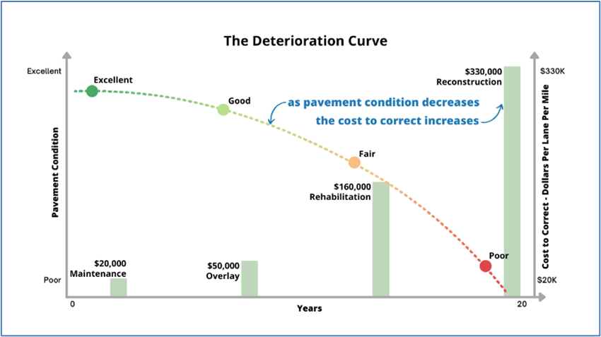
The data will be transparent and can be shared with citizens to assure them that budgets are being spent in the most optimal way. It is important to also include an explanation about the strategic choices made in the pavement plan. People are not always aware of the Deterioration Curve (as shown in figure 3), which shows that in the long term it is much more cost efficient to spend the limited available budget on roads which are not yet in terrible condition.
By fixing roads that are just beginning to degrade, total pavement life is extended, thus maximizing the value of each dollar spent on the roads. Another important benefit of the pavement preservation approach is that it enables the preservation of four to ten times more streets than if resources were used to fixing the ‘bad’ roads first, since the treatment cost to preserve ‘good’ roads is substantially less. An overall increased PCI scoring based on high-quality data will prove the strategy is working.

Persistence is Key
Be patient! Although the results of such a long-term strategy might not show after the first year, the longer-term results of a Data Driven Pavement Preservation Strategy will soon become clearly visible to your citizens. In the end, it will show that you live in a Smart City, and less budget will be needed in the long term. “And yes, I do realize that waiting is often difficult, especially when politics play a role in locations where road maintenance must be done,” says Doekele, “but a challenging situation such as preserving the roads is one that must be tackled.”
More and more cities and counties are realizing that a Data Driven Pavement Preservation Strategy is the way forward, and that new technologies are key. The beauty of AI on Imagery and LiDAR is that you can not only visualize road surface damage, but also map the other assets in the right-of-way and use it for condition assessments of traffic signs and road marking using the LiDAR intensity as a retro-reflectivity value. Stay tuned for the next blog post, which will cover this topic.